New MAX-N Local Charts Provide Jeppesen Cartography
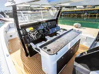
Jeppesen's new C-MAP MAX-N Local chart release for the EMEA region is made for two things -- compatibility with popular navigation systems from and the demands of cruisers, sailors and fishermen throughout Europe, the Middle East and Africa. New MAX-N Local charts will deliver an enhanced navigation experience to owners of Lowrance Elite 7 and HDS Gen1, Gen2 and Gen2Touch, Simrad NSS, NSE and NSO, and B&G Zeus Touch Multifunction Navigators.
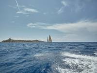
Jeppesen's launch of MAX-N cartography puts a new level of accurate chart data and detailed information at the fingertips of boaters navigating the Atlantic European Coasts, North and Baltic Seas and Mediterranean/Black Sea. New MAX-N Local charts detail port plans for this important region of the world, and Jeppesen's MAX-N Local charts deliver coverage explore fishing, diving and cruising spots.
MAX-N Local charts feature up-to-date data from official sources, with depth areas and contours, spot soundings, nav aids, light sectors, wreck/obstructions, anchorage areas, small craft facilities and more.
These charts also provide clearly marked boundaries for restricted, caution, fishing and prohibited areas for the region, helping boaters and fishermen stay out of danger and on the right side of local regulations.
Jeppesen's MAX-N Local charts are available immediately on preprogrammed micro SD cards (with adapter) through Jeppesen dealers or online via Jeppesen Direct. In the near future, MAX-N Local charts will also be available for download directly through the Navico Insight Store (InsightStore.Navico.com).